In an effort to improve its efficiency, the Public Infrastructure Ministry has introduced a new computerised system to quickly and accurately collect pavement and asset data.
The Ministry recently acquired this system in a bid to improve its data collection capabilities. The new system, ROMDAS (Road Measurement Data Acquisition System) is the most up-to-date technology used to collect data on roadways, and its introduction to Guyana will see significant improvements in the micro-planning of road projects.
This is according to the Ministry’s Chief Transport Planning Officer, Patrick
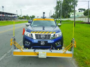
The ROMDAS data collection technology outfitted on a Public Infrastructure Ministry vehicle
Thompson, who said that the system has “tremendous potential” to improve the planning and decision-making of road maintenance and rehabilitation works.
He explained that the decision to introduce the system at the Ministry came in light of issues encountered over the years with the sustainability of data collection procedures. He said, following the identification of this problem, the decision was made to look into available technologies and decide which would be best suited for Guyana’s needs.
The ROMDAS technology is used in approximately 60 countries around the world, with four countries in Latin America currently utilising this New Zealand developed technology.
“One of our fundamental problems in the Ministry is the absence of accessible data. The absence of reliable data often results in poor planning and decision-making; data is essentially the reality of the situation in numbers,” Thompson explained. He continued, “Too many times we have found ourselves estimating or guessing in the absence of reliable data; now, we can make firm, irrefutable future decisions in the road sector if this technology is optimally utilised.”
He noted that the system utilises a number of laser sensors, a bumper integrator, Global Positioning System and a right-of-way camera to carry out automatic crack and defect measurements, pavement roughness measurements, mobile mapping of the road corridor and travel time and congestion surveys.
Among other things, the Ministry hopes to use the ROMDAS equipment to create a geo-referenced database of Guyana’s primary and secondary road network within the next 12 months.
The technology’s video logging feature will improve the Ministry’s asset management capabilities and allow for more effective road safety interventions in the future.
In a bid to maximise the technology’s use, 12 persons from the Ministry and one final-year student from the University of Guyana undertook a 10-day training conducted by Krishna Jammalamadaka, Director of Research and Development of ROMDAS, New Zealand. The training included both the theoretical, practical and safety instructions required to optimise the use of the technology.