

One of the leading drone companies in Guyana, Caliper Drone Services, has mapped the Le Repentir Cemetery in Georgetown using drone technology and geographic information systems (GIS), with the aim of demonstrating how digital tools could help families locate the graves of loved ones and improve the management of the country’s largest burial ground. The project comes as the Government of Guyana undertakes a $350 million programme to clear vegetation at Le Repentir Cemetery and other burial grounds across the country. Established in 1861 the historic Le Repentir cemetery is Guyana’s largest cemetery. It has more than 10,000 tombs spread across an area exceeding 100 acres.

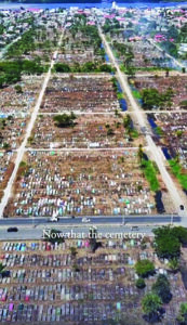
But with the cemetery constantly encumbered by overgrown vegetation obscuring tombs and pathways, Le Repentir Cemetery has long presented challenges for families attempting to locate graves.
The latest clean-up effort has created an opportunity for the mapping exercise, as the removal of vegetation makes it easier to identify tombs and document their locations.
The cemetery mapping project is intended to demonstrate how technology developed and applied locally could help address practical problems, while opening the door for greater adoption of digital tools by public agencies.
Local Government and Regional Development Minister, Priya Manickchand had previously acknowledged the number of requests she has received from people seeking help to find relatives’ graves. In a post on social media, she praised the work being done by Caliper Drones, and noted that her Ministry is looking forward to working along with the company to get the initiative done.
“I have gotten so many messages with persons asking me if I could help find the tombs of their families and I have promised each and every one to go and search for them. Looking forward to working with you sir,” the Minister said.
Long-term vision
Speaking with Guyana Times in a telephone interview, Chief Executive Officer (CEO) and Technical Director of Caliper Drones, Julian Cadogan, said the project builds on his work in GIS and his interest in demonstrating how technology could be incorporated into the delivery of public services in Guyana.
“A big part of my work is using GIS. We spent a lot of time training various organisations about how it can be used for their work, so for example, we’ve trained GGMC (Guyana Geology and Mines Commission) on how it can be used to do mapping of their properties. And how drones can help in the process. So I was just able to translate that over to a cemetery,” Cadogan shared.
The initiative is also part of Cadogan’s work in developing drone and GIS technology in Guyana. He said the company had previously worked on similar application development in other countries.
“We have done some work on developing similar apps in Kenya and Brazil. So this is just some continuation of the work that we are doing,” he said.
Cadogan said that aside from the mapping of the cemetery, the long-term vision is to create an app that would allow members of the public to search for relatives buried at the cemetery and receive directions to their graves.
The proposed application could be useful to people who have difficulty navigating the extensive cemetery or who do not know the precise location of a family member’s tomb.
Interest in the initiative has already emerged following Cadogan’s public post about the mapping exercise, with people contacting him for assistance in locating relatives.
“Since posting a few people have messaged me asking if I can help them find family members. So the idea is to create an app so that people can search for their loved ones. The idea is that you will be able to go to the app to search for their names or other information and be able to navigate towards the tombs,” he said.
Apart from helping relatives find graves, the proposed system could also support cemetery administration by recording the condition of tombs, identifying available burial plots and assisting with the monitoring of space for future burials.
Drone mapping and GIS
Cadogan explained that drone mapping and GIS could be used to identify deteriorating tombs and areas requiring maintenance, while providing cemetery managers with a clearer picture of the burial ground.
He related that the idea to map the cemetery had been on his mind for some time, but the persistent overgrowth at Le Repentir Cemetery had made it difficult to undertake the mapping exercise.
“This year I have the time so we wanted to explore some new initiatives. It’s something that I’ve wanted to do for a very long time, but the cemetery have obviously always been overgrown so since they are clearing it, I took the opportunity to go and map it and show how the drones can be used because I think a lot of the Government agencies can benefit from using technology in their services,” Cadogan explained.
The mapping exercise involved capturing the cemetery from end to end, allowing individual tombs to be identified and their locations recorded. Under the concept being developed, each gravesite would receive a location reference comprising a section, row and plot number.
However, he stressed that the application itself remains a concept that would require collaboration with the relevant authorities, particularly to obtain the information needed to link individual graves to the people buried there.
“What I presented is a concept we would have to work with the Ministry of Local Government, or whoever is responsible for that, so that we could be able to get the relevant information about the graves and create the app,” Cadogan said.
“I am excited”
Cadogan said the mapping work and the proposed digital platform could provide a foundation for a more comprehensive system.
“We have a full mock up for the app. We have a dashboard on the app and can be ready to go live. It’s just a matter of collaborating with the Ministry to get the relevant data,” he said.
“I am excited about this project. I think it’s something that will definitely benefit Guyanese both locally and abroad and I think it’s a good step to encourage other Government agents to continue adopting technology.”
The proposed digital database could provide a more systematic means of responding to such requests, provided the relevant burial records and other information can be obtained and incorporated into the platform.
He added that he had made time this year to explore new initiatives, including practical applications of technology to address local challenges.
Cadogan also encouraged individuals and organisations interested in drone technology and GIS application development to make contact with the company.
“We work to develop drones and GIS software in Guyana. So if anyone is interested in drones or developing an application that uses GIS then feel free to reach out to me,” he said.
Discover more from Guyana Times
Subscribe to get the latest posts sent to your email.