

By Amar Persaud
It has been some two years since the country became an oil-producing nation, and the Environmental Protection Agency (EPA) has moved closer towards conducting “real-time” monitoring of offshore activities, to ensure compliance with the necessary protocols.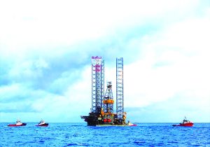
This position was shared by EPA Deputy Executive Director Sharifah Razack, Head of the EPA Oil and Gas Unit Joel Gravesande, and EPA Geographic Information System (GIS) Specialist Reshana Thomas during a recent episode of the programme “Environment Matters”.
Razack explained that one of the Agency’s plans for the new year is to be able to completely monitor, in real-time and remotely, the activities offshore.
“We are planning to strengthen our capabilities to monitor remotely, and we are putting systems in place to do that; subscribing to various services that can allow us to tap into their resources to have remote monitoring of the marine environment, the terrestrial environment, so that we can know what’s going on in the environment as a whole,” she explained.
“We are going to utilise GIS in order to identify high-risk industries, high-risk projects, and to keep a closer look at them; and also to identify hotspots in different sectors where we need to keep a close look; and to monitor what’s going on,” she added.
Expanding on this point, Gravesande noted that performance of the Oil and Gas Unit has improved tremendously since its establishment. The Unit has a staff complement of twelve persons.
“Having such a large department allows the Agency to have focus on the specifics. There are persons that overlook water quality for both exploration and production; there are persons dedicated to monitoring waste management, air and climate change,” he explained.
In addition to doing physical monitoring offshore, the EPA has been moving towards remote monitoring of the oil activities.
“We have tried to move more now towards remote monitoring… We have moved towards compliance monitoring, real satellite data monitoring. The Agency now has the ability to [almost] conduct real-time monitoring of the ships… We use satellite programmes such as ‘Sky Truth’,” he revealed.
“So, added to the satellite monitoring, which is daily, even though we get alerts if something should happen offshore, we take it upon ourselves to conduct real-time data monitoring. This is something that we’re working on to bring completely full circle by the end of this month, whereby the Agency would have the ability to monitor real-time what is happening offshore in the oil-production facilities.
“I’m talking about volume of gas being flared, the quantity of produced water being discharged…the whole nine yards. The Agency will have live access to this information,” Gravesande added.
In addition to these monitoring techniques, he explained, oil and gas companies are required to submit self-monitoring reports.
“They submit self-monitoring reports that are required based on the environmental authorisation that is issued to them,” he explained.
Further weighing in on the matter, Thomas explained how Sky Truth has been aiding the Agency in its monitoring activities.
“We have utilised a lot of opensource data, freely available from Sky Truth, that allows us to visualise and quantify daily flaring…we are also making use of an experimental tool from Sky Truth, but what it does, it automates the detection of oil slicks or any oil spills offshore…
“Because of Sky Truth’s advancements, they’re able to get the imagery within three hours of an image being taken. So, it’s not real-time, but it’s (as) near real-time as you can get,” she noted.
Moreover, Thomas explained that the EPA utilises data from NASA to “monitor some parameters”.
Efforts are also ongoing by the EPA to monitor other projects outside of the oil and gas industry, such as mining and forestry. Thomas noted that the Agency is working in collaboration with the Ministry of Natural Resources in this regard.
“Some of the very exciting things we are looking to do in 2022 are: we have started engaging with, and soon (it) will probably become public, once those agreements are finalised. We have, in collaboration with the Ministry of Natural Resources, to engage some commercial satellite imagery- providers. What is exciting about what they are able to do is, in addition to providing us near real-time access to imagery catalogs, we’re also able to tell that we’re interested in monitoring in these particular areas and we would like to get a weekly or a daily report of what is happening here.
“So, not only will they be providing a satellite imagery visual product to us, they will be providing some analysis-ready data. For example, they’ll tell us if there has been a detection of something that is not water on the surface of the water…” she explained.
“That’ll help us even before something is formally reported. The Agency can be ahead of it, and that adds to the proactive approach that the Agency is sort of taking in monitoring our offshore and even onshore activities,” the GIS specialist added.
Discover more from Guyana Times
Subscribe to get the latest posts sent to your email.